Qinghai Lake (青海湖) is China’s largest inland lake — a high-altitude saltwater sea on the Tibetan Plateau at 3,196 metres above sea level, 105km long, 63km wide, and an extraordinary shade of deep blue that intensifies as you go further from the developed eastern shoreline. The circumnavigation route around the lake is approximately 360km, follows the route of the professional Tour of Qinghai Lake race, and is one of the finest multi-day cycling routes in China.
You don’t need to be a competitive cyclist to do this. You need to be reasonably fit, acclimatized to the altitude, properly equipped, and realistic about daily distances. Many cyclists complete the full circuit in 3–4 days; others take 5–6 days for a more relaxed experience that includes time to stop, photograph, and talk to the Tibetan nomad families along the way.
Table of contents
Open Table of contents
Why Cycle Qinghai Lake
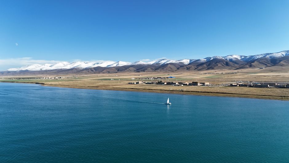
The appeal is threefold. First, the landscape: the combination of the blue lake, the snow-capped Qilian Mountains to the north, and the open grassland plateau is genuinely magnificent — the kind of scenery that makes you feel like you’re cycling through a screensaver rather than reality.
Second, the route quality: the 360km circuit road is mostly paved (Highway G109 and provincial roads), the traffic is manageable except on the eastern section closest to Xining, and the terrain is rolling rather than relentlessly mountainous, with the highest point on the circuit around 3,600m.
Third, the cultural encounter: the western and northern shores pass through Tibetan nomad territory where the landscape is still being used by families grazing yaks and sheep as it has been for centuries. The interaction with that pastoral life — stopping at a nomad tent for buttered tea — is part of what makes this route exceptional.
Altitude Reality
At 3,196m, Qinghai Lake is high enough that altitude affects cycling performance significantly. A cyclist who can average 80km per day at sea level should plan for 60–70km per day here, at least for the first two days. The body acclimatizes gradually, and most cyclists find their performance improving from day 3 onwards.
Minimum acclimatization: Spend 2–3 days in Xining (2,261m) before starting the cycling. Xining is lower than the lake, but spending time at any elevation before going higher is beneficial.
Symptoms to watch for: Beyond normal cycling fatigue, watch for persistent headache, unusual breathlessness (beyond what the physical effort explains), and poor sleep. These are normal altitude effects that improve with rest. Descent is the cure for anything more serious.
Food and water intake: At altitude, you need more carbohydrates than you think and more water than you think. Carry energy bars or dried fruit for between villages, and aim for 3 litres of water per day.

Route Stages for Independent Cyclists
The standard approach divides the 360km circuit into 3 main stages from the eastern entry point at Heimahe Village on the southern shore, moving clockwise (north then west then south and back east).
Stage 1 — Heimahe to Shadao Scenic Area (approximately 80km): This is the most photographed section, with the lake visible for most of the route and several access points to the shoreline. The road quality is good throughout. There are guesthouses in Heimahe (start), and at Bird Island area (65km mark). Elevation change: minimal.
Stage 2 — Shadao to Gangcha County Town (approximately 100km): The northern shore section. Less lake-side road, more grassland interior, and the most Tibetan cultural immersion. Gangcha County Town (刚察县) is the largest settlement on the circuit with full services — restaurants, pharmacies, guesthouses, bike repair shops. Budget 1 night here.
Stage 3 — Gangcha to Heimahe via the western shore (approximately 180km): The longest stage is best split over 2 days. The western shore has the fewest services and the most remote feeling. Carry food. The town of Tianjun (天峻县) midway offers basic accommodation. The return section along the southern shore passes through the rape flower fields that are spectacular in July.
Bike Options: Rent in Xining or Bring Your Own
Renting in Xining: Several bike rental shops in Xining near the main backpacker hostels rent touring and hybrid bikes specifically for the Qinghai Lake circuit. Rental rates: ¥80–¥150 per day for a decent touring bike with helmet, rear rack, and basic tools included. Deposit required (usually ¥500–¥1,000). The rental quality varies — inspect the bike carefully, especially brakes, gears, and tyres, before accepting.
Recommended rental areas: the Youth Hostel district near Xining West Train Station has multiple operators who know the route and can advise on current road conditions.
Bringing your own: A good option if you have a folding bike or are arriving by train (fold-and-carry bags work well on Chinese trains). You know your own bike’s performance and have already fitted it to your needs. The downside is managing transport on the Xining-lake section at the start and returning at the end.
What type of bike: A touring bike or sturdy hybrid is ideal. Road bikes work on the main circuit road but are uncomfortable on the gravel sections near the lake shoreline. A mountain bike is fine but slower. Avoid city bikes and cheap rentals with poor components.
Best Months and Weather
June: The rape flower fields on the southern shore are at peak bloom, creating carpets of yellow that photographers specifically target. Weather is generally pleasant (15–22°C daytime) but occasional rain. The Tour of Qinghai Lake race begins in mid-July, so June avoids road closures.
July: The professional race (held in July) closes sections of the route for specific days. Otherwise, July offers the warmest and most stable weather. The lake is at its deepest blue.
August: Good weather, but the most crowded month — Chinese summer holidays bring large numbers of domestic tourists and rental bike availability tightens.
September: Fewer crowds, stable weather, autumn colour beginning in the grasslands. An excellent choice.
May and October: Possible but cold. Temperatures at night can drop below 0°C and snow is possible at higher sections. For experienced cold-weather cyclists only.
Practical Logistics
Xining to the lake: The most common start point is the town of Huangyuan or Heimahe on the eastern/southern shore. Buses run from Xining’s West Bus Station (西客站) to Qinghai Lake area for ¥25–¥50; journey time approximately 2 hours. Some cyclists ride from Xining to the lake directly (95km), but this involves significant traffic on Highway G109.
Accommodation along the route: Basic guesthouses (¥80–¥150 per night) exist in most settlements on the circuit. Camping is also possible on the grassland sections with a tent.
Food: Small Tibetan-run restaurants in villages along the route serve noodles, tsampa, yak meat dishes, and butter tea. Budget ¥30–¥60 per meal.
Circuit time: 3 days (ambitious but possible for fit cyclists), 4–5 days (comfortable), or 6+ days (leisurely with side trips).