Tibet’s most profound journeys are its most demanding. Two destinations stand apart for their combination of altitude, remoteness, and spiritual significance: the circumambulation circuit around Mount Kailash (冈仁波齐) — the most sacred mountain in Asia, revered by four religions — and the overland route to the north side Everest Base Camp (珠穆朗玛峰大本营) at 5,200 metres. Both require permits, planning, and genuine respect for altitude.
Table of contents
Open Table of contents
Tibet Entry Requirements
Tibet Travel Permit (西藏旅游许可证): All foreign nationals require this permit in addition to a valid Chinese visa. Cannot be obtained independently — must be arranged through a registered Tibet travel agency. Processing time: 5–15 working days.
Alien’s Travel Permit (边境地区特别许可证): Required for areas west of Lhasa (Shigatse, Ngari Prefecture for Kailash). Must be arranged through the same agency.
Military Zone Permit (军事区许可证): Required for some border areas near Kailash and Everest. Your agency arranges this.
Practical note: All Tibet travel for foreign nationals must be arranged through a licensed Tibet travel agency (this is Chinese law, not a recommendation). Agencies organise the permits, guide, and vehicle; you pay a daily guide fee on top of your own costs.
Mount Kailash (冈仁波齐) and Lake Manasarovar
The sacred mountain
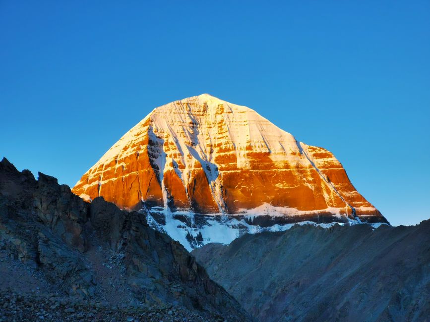
Mount Kailash (6,638m) is the most sacred mountain in Asia: simultaneously the axis mundi of the universe in Tibetan Buddhism, the dwelling of Shiva in Hinduism, the source of four great rivers in the Bon tradition, and significant in Jainism. Hundreds of thousands of pilgrims — Tibetan, Indian, Nepali, and Chinese — have circumambulated the mountain over the centuries. No one has ever climbed it; by religious consensus, climbing would be sacrilege.
The mountain itself is visually remarkable: a near-perfect four-sided pyramid of black rock rising above the plateau, permanently snow-capped, symmetrical from all four cardinal directions.
The Kora (circumambulation circuit)
The Kailash kora (转山 in Chinese) — the 52km circuit around the mountain — is one of Asia’s most significant pilgrimage walks. At altitudes of 4,700–5,630m (the Dolma La pass at 5,630m is the high point), the walk typically takes:
- Tibetan pilgrims: 1 day
- Well-acclimatised hikers: 2–3 days
- Standard trekkers: 3 days
Day 1: Darchen base (4,700m) → Diraphuk Monastery (5,000m); approximately 22km Day 2: Diraphuk → Dolma La Pass (5,630m) → Zutulphuk Monastery (4,760m); approximately 15km, most challenging Day 3: Zutulphuk → Darchen; approximately 14km return
Altitude note: This is serious altitude. Anyone attempting the kora should have spent at minimum 5–7 days in Lhasa (3,650m) acclimatising before travelling to Kailash. The Dolma La pass at 5,630m will be genuinely difficult for most non-acclimatised visitors.
Lake Manasarovar (玛旁雍错)
Adjacent to Kailash, Lake Manasarovar is one of the world’s highest freshwater lakes at 4,590m. The sacred lake features in all four of the religious traditions that revere Kailash. The pilgrimage circuit of the lake (100km) takes 3–4 days.
The turquoise-blue lake surrounded by high-altitude desert, with Kailash visible to the north and other snow peaks on three sides, is one of Tibet’s most visually overwhelming landscapes.

Everest North Base Camp (珠峰北坡大本营)
Overview
The north face of Mount Everest (8,849m) is accessible from Tibet — the approach road from Shigatse (日喀则) crosses the Gyatso La pass (5,248m) and reaches Rongbuk Monastery and the base camp at 5,200m. Unlike the Nepal south side (which requires a full expedition permit and is only accessible on foot), the Tibet north side is accessible by vehicle — you can literally drive to Everest Base Camp.
The base camp experience: from the base camp, Everest rises in a near-perfect triangular profile above a glacier. The north face — 3,600 vertical metres of mixed ice and rock — is fully visible. The scale is comprehensible in a way that’s harder to appreciate from sea level. Everest’s summit plume (wind-driven snow streaming from the peak) is visible on most clear days.
What’s at Base Camp
Rongbuk Monastery (绒布寺): at 4,980m, this is the world’s highest monastery, in continuous use since 1902. A small monastic community of Tibetan monks and nuns lives here year-round. Simple guesthouse accommodation available (¥100–¥200/night); staying overnight gives access to the spectacular sunrise light on the north face.
Base camp facilities: simple tent restaurants and shops operate from April–September. Basic facilities (toilets, instant noodles, tea). No electricity; cold nights (temperature drops to -10°C even in summer). Altitude sickness can be severe; oxygen canisters are sold at the base camp.
Getting to Everest
Route from Lhasa:
- Lhasa → Shigatse: 280km, 3–4 hours on the Lhasa-Shigatse Expressway
- Shigatse → Tingri (定日): 230km, 3–4 hours on G318 highway
- Tingri → Rongbuk / Base Camp: 90km on a mountain road, 2–3 hours
Total: 600km, can be done in 2 days with a stop in Shigatse. The standard Tibet travel agency itinerary for Everest adds 2–3 days to a Lhasa-based trip.
Entrance fee: ¥180 per person for the base camp area. An additional environmental protection deposit may be required.
Best Season
For Kailash
May–June: best clear weather before monsoon clouds build; trails snow-free by late May September–October: after monsoon; excellent clarity; fewer pilgrims than summer
Avoid: July–August (heaviest monsoon; Dolma La pass can be dangerous in wet conditions); December–March (extreme cold, roads may close)
For Everest
April–May: pre-monsoon climbing season; base camp full of summit expedition teams; Everest visible most mornings September–October: post-monsoon; fewer people, clear air, good views
Altitude and Health
At these altitudes, everyone is affected. Specific risks:
Acute Mountain Sickness (AMS): headache, nausea, fatigue, insomnia. Expected at 3,650m; significant at 4,000m+; potentially serious at 5,000m+.
High Altitude Pulmonary Edema (HAPE) and High Altitude Cerebral Edema (HACE): rare but life-threatening complications. Descend immediately; evacuate.
Protocol for Tibet travel:
- Spend 2 nights in Lhasa (3,650m) before travelling higher
- Ascend gradually: no more than 500m elevation gain per day above 3,000m
- Drink 3–4 litres of water daily
- Avoid alcohol and sleeping pills
- Carry Diamox (acetazolamide); consult a doctor before trip
- Know when to descend — HAPE and HACE are not things to push through
Last updated: May 2026 · Tibet permit regulations may change; verify current requirements through a licensed agency before travel. Kailash and Everest routes require advance planning.