
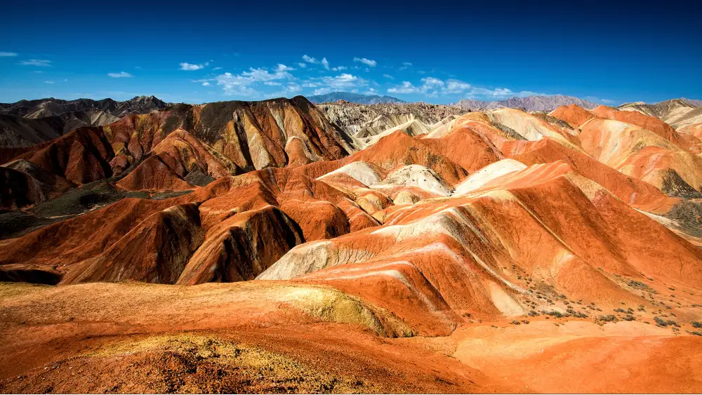
The Zhangye Danxia (张掖丹霞地貌) — known internationally as the “Rainbow Mountains” — is one of China’s most visually extraordinary landscapes: multi-coloured rock formations created by 24 million years of mineral-rich sediment deposition, erosion, and tectonic uplift. The colours range from deep crimson and orange to purple, blue-grey, and cream, sometimes striated in layers mere centimetres thick.
The landscape became internationally known after appearing in a National Geographic feature — and has since become one of the most photographed natural sites in China.
Getting to Zhangye
From Xi’an: HSR to Zhangye Xibai station (7 hours). Xi’an → Lanzhou (2.5 hours) → Zhangye (2.5 hours more). Or Xi’an → Zhangye direct on some trains.
From Lanzhou: HSR to Zhangye (1.5 hours). Lanzhou is the Silk Road hub — most visitors incorporate Zhangye into a Lanzhou–Dunhuang circuit.
From Dunhuang: The reverse of the above — train Dunhuang → Liuyuan → Zhangye (3–4 hours by various connections).
Staying in Zhangye: Stay in Zhangye city (1 hour drive from the park). The park itself has no accommodation.
Inside the Park
The Danxia National Geological Park (国家地质公园) covers three main areas: Danxia Colourful Landform (彩色丹霞), Binggou Danxia, and Linze Danxia. The Colourful Danxia area is the primary destination for most visitors.
The Four Main Viewpoints
The park has a shuttle bus system connecting the viewpoints (mandatory for visitors — no private vehicles inside).
Viewpoint 1 (一号观景台): The most visited. The ridgeline facing east gives the primary layered colour photograph at sunset. This is the viewpoint in most “Rainbow Mountains” imagery.
Viewpoint 2 (二号观景台): Slightly different angle, slightly lower elevation. The colour banding is more pronounced from this angle in morning light.
Viewpoint 3 (三号观景台): Higher elevation, broader panorama. Shows the full extent of the Danxia formation — the 40km+ expanse of coloured rock.
Viewpoint 4 (四号观景台): The “Qicai Waterfall” (七彩瀑布) area — small seasonal waterfalls running over the coloured rock face. Only active after significant rainfall.
Light and Photography
The colour intensity changes dramatically with light angle:
Best light: Late afternoon (2 hours before sunset) and the first hour of morning light produce the most saturated colours — low-angle light emphasises the layering and maximises the saturation of the mineral colours.
Avoid midday: Overhead noon light flattens the colours and creates harsh shadows. The formations look disappointingly grey-brown in flat midday light.
Cloud: Partial cloud with sun breaks creates dramatic shadow/light contrasts across the formations — arguably the most spectacular condition for photography.
After rain: Wet rock enhances colour saturation significantly. The hour after a shower passes is often the most vivid colour experience.
Best Season
Year-round: The park is open all year. The formations are present regardless of season.
Best months: July–September (summer/early autumn). The sky is clearest after July storms; the surrounding desert landscape provides the most dramatic contrast.
Avoid: Major Chinese holidays (Golden Week, etc.) for crowd reasons. Winter (December–February) is cold (-15°C) but uncrowded.
The Silk Road Circuit
Zhangye fits naturally into a Gansu Silk Road circuit:
Xi'an → Lanzhou → Zhangye (Danxia) → Jiayuguan (last Great Wall pass) → Dunhuang (Mogao Caves) → Urumqi (Xinjiang)This 10–14 day circuit represents one of China’s most historically and visually extraordinary travel routes — the full Silk Road corridor from the Tang dynasty capital to the Xinjiang border.
Also see: Gansu Silk Road Guide | Dunhuang Mogao Caves Guide | Jiayuguan Great Wall Guide