Detian Transnational Waterfall: Standing Between China and Vietnam
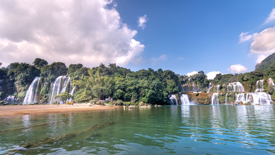
In the far southwest of Guangxi, where the Guichun River curves along the Vietnamese border, one of the world’s most extraordinary waterfalls drops 70 metres in multiple tiers across a landscape of limestone karst formations draped in tropical vegetation. Detian Waterfall (德天跨国大瀑布) — known on the Vietnamese side as Ban Gioc Falls — is the world’s fourth largest transnational waterfall by volume and the largest in Asia.
What makes Detian unique is not just its scale but its geographical and political drama: the international border runs directly through the waterfall itself, meaning that from the Chinese side you can see — and sometimes hear — Vietnamese tourists on bamboo rafts on the opposite bank, with only the white water of the falls between two nations.
Geography: How a River Became a Border
The Guichun River was designated as the boundary between China and Vietnam (then French Indochina) by the Sino-French Border Treaty of 1895. The treaty placed the borderline down the middle of the river — which, at Detian, crosses the lip of the falls.
This means:
- The main left cascade is entirely in China (Guangxi).
- The right cascade is partially in Vietnam.
- Bamboo raft tours from both sides approach the centre of the falls from their respective banks; at the closest point, Chinese and Vietnamese tourists are literally a few metres apart.
The river below the falls curves through a wide pool before re-entering Vietnamese territory. The entire landscape — karst hills, river valley, rice paddies on both banks — is visually indistinguishable from classic northern Vietnamese scenery around Cao Bang.
The Waterfalls
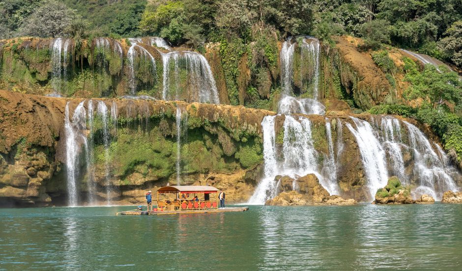
Detian actually consists of three distinct cascades dropping in stages across a 120-metre width:
First Cascade (Daxin Side)
The tallest single drop (approximately 40 metres). This is closest to the Chinese entrance and the most dramatically vertical.
Second and Third Cascades
Separated by rocky outcrops and vegetation; the second cascade spreads wider and lower; the third is more braided and seasonal, sometimes reduced to a trickle in dry months (February–April).
Volume: During peak season (July–September, monsoon fed), approximately 60 million litres per hour — generating a permanent mist cloud visible 2 km away. In dry season the flow reduces significantly; call ahead or check social media updates before timing a visit to coincide with high water.
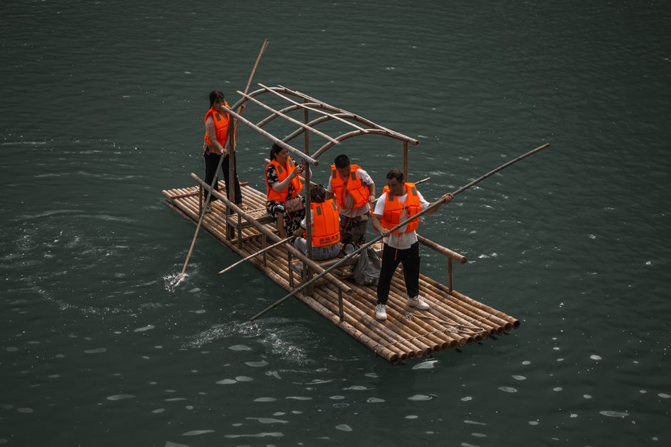
Bamboo Raft Tours
The signature experience at Detian is the bamboo raft ride into the mist spray zone at the base of the falls. Traditional wooden-pole rafts, each holding 3–4 passengers and a helmsman, launch from below the first cascade and work their way upstream along the Chinese bank until the spray is heavy enough to require rain ponchos.
At the closest point — roughly 30 metres from the main curtain — the sound is overwhelming and the mist turns the air white. Vietnamese rafts from the Ban Gioc side are often visible in the spray, creating the extraordinary spectacle of two countries’ tourists soaked simultaneously by the same waterfall.
Cost: ¥80 per person (30-minute round trip). Note: Ponchos are provided but largely ineffective at full flow; wear clothes you don’t mind getting wet. Water shoes or sandals are ideal.
The Surrounding Landscape
Karst Formations
The valley surrounding Detian is classic Guangxi karst — the same needle-limestone formations that make Guilin and Yangshuo famous, here draped in denser subtropical vegetation and largely unvisited by the crowds that fill those more accessible parks.
A 3-km riverside walking trail follows the Guichun River upstream from the scenic area entrance, passing through bamboo groves, limestone outcrops, and villages where Zhuang minority farmers tend terraced rice fields. The trail is unflagged and often muddy but entirely walkable without a guide.
Ming Dynasty Border Marker
At the base of the falls, visible on a rock outcrop above the waterline, is a stone stele erected in 1883 marking the Sino-French border. The marker predates the formal 1895 treaty; its inscription in classical Chinese proclaims the boundary with the formal gravity of imperial administration. It has been photographed by every visitor for 140 years and, remarkably, remains largely intact.
Practical Information
Getting There
Detian Waterfall is located in Daxin County (大新县), Guangxi — roughly 160 km southwest of Nanning.
From Nanning:
- Direct tourist buses depart Nanning South Bus Station at 8:00 AM daily (peak season), returning at 17:00. Journey: 2.5–3 hours each way. Cost: ¥60–¥80 round trip including basic scenic area entrance.
- Alternatively, self-drive or taxi charter (¥400–¥600 round trip from Nanning); allows more flexibility to explore Daxin County’s secondary sights.
From Chongzuo City (崇左): Chongzuo is 80 km from Daxin; taxis to the scenic area take 1.5 hours (¥180–¥250).
Admission
¥90 (Chinese scenic area entrance; includes riverside paths and viewing platforms). Bamboo raft ¥80 additional. Total typical spend: ¥200–¥250 per person.
Best Time to Visit
| Season | Conditions |
|---|---|
| July–September | Peak flow; most dramatic; hot and humid; occasional tropical storms |
| October–November | Good flow; cooler; clear skies; ideal for photography |
| December–March | Reduced flow; clear weather; cooler temperatures (15–20°C) |
| April–June | Increasing flow; green landscape; Chinese national holidays create crowds |
Combining with Nearby Sights
Tongling Grand Canyon (通灵大峡谷)
45 km northeast of Detian; a narrow karst gorge with a second impressive waterfall (Tongling Falls, 216 m) accessible via a carved-rock walkway. Often combined into a 2-day Daxin County itinerary.
Enhe Border Trade Zone
The official Sino-Vietnamese border crossing town, 40 km south. Not a tourist visa crossing, but the small market town has genuine border atmosphere: Vietnamese traders, local product stalls, and a sense of frontier liminality.
Black Water River (黑水河) Source
A spring emerging directly from a limestone hillside producing extremely blue water — deep azure due to mineral content. Locals operate boat tours from the spring head downstream through karst caves.
The Vietnam-China Border Experience
Standing at Detian you are, practically speaking, very close to Vietnam: Cao Bang Province begins immediately across the water, and the town of Ban Gioc (Vietnamese name for the same waterfall) is visible downstream. Vietnamese and Chinese visitors are sometimes close enough to wave to each other.
This proximity is mostly purely visual for Chinese passport holders — crossing the border at Detian requires specific border trade permits not available to tourists. But the experience of standing at an international boundary defined by a waterfall is unusual enough to be worth noting: nature, here, was a more honest cartographer than any treaty negotiator.
Detian is what happens when extraordinary natural geography collides with the accidental geometry of national borders — a waterfall that belongs to two countries and is diminished by neither.