Table of contents
Open Table of contents
Understanding Altitude in Qinghai
The Acclimatisation Imperative
Before discussing any specific treks, altitude must be addressed. Most trekking destinations in Qinghai are at 3,500–5,500 metres. At these elevations, the partial pressure of oxygen is significantly reduced:
- At 3,500m (Xining + surrounding areas): 65–70% of sea-level oxygen
- At 4,200m (typical grassland base): ~60% of sea-level oxygen
- At 5,000m (Yangtze source area): ~52% of sea-level oxygen
Altitude sickness (acute mountain sickness or AMS) is a genuine danger, not a talking point. Cerebral and pulmonary oedema, the severe forms, can be fatal within hours without descent.
Minimum acclimatisation protocol:
- Spend 2–3 nights in Xining (2,276m) on arrival before travelling to higher areas
- Ascend no faster than 300–500m gain per day above 3,000m
- Follow the rule: “climb high, sleep low”
- Carry acetazolamide (Diamox) — consult a physician before departure
- Know the symptoms and have a clear plan for descent
Altitude Sickness Symptoms
Mild AMS: Headache, fatigue, nausea, dizziness — rest and don’t ascend further Severe AMS / HACE: Confusion, ataxia (staggered walk), severe headache — descend immediately HAPE: Pink frothy cough, shortness of breath at rest — descend immediately, medical emergency
Major Trekking Areas
1. Bayankala Mountains and Yangtze Source (巴颜喀拉山 / 长江源)
The Bayankala range in central Qinghai forms the watershed between the Yellow River and the Yangtze basin. The Yangtze’s ultimate source — the Dangqu tributary spring at 5,042 metres — was definitively identified in 1976, though there’s ongoing academic discussion about the precise ultimate source point.
Trekking in this area typically operates from the small town of Yushu (玉树), at 3,700m, which serves as the logistical hub for the Sanjiangyuan (Three River Sources) region.
The Sanjiangyuan National Park (三江源国家公园) covers 395,000 square kilometres — larger than Germany — and was China’s first national park, established 2016. Entry to the core zones requires permits arranged through the park administration in Yushu.
Typical routes:
- Yangtze Source Trek: 5–7 days from Yushu to the Tuotuohe source area via the Bayankala; requires 4WD support vehicle and guide
- Yellow River Source (扎陵湖-鄂陵湖): Shorter access; the twin Zaling and Eling lakes at 4,260m mark the Yellow River’s early course. Day hikes possible from the road.
Permits: Sanjiangyuan National Park core zone permits required; arrange through Qinghai provincial tourism bureau or via specialised agencies in Xining. Allow 2–4 weeks lead time.
2. Kekexili (可可西里)
The Hoh Xil Nature Reserve — Kekexili in Tibetan — is one of the world’s most strictly protected wilderness areas. At 45,000 square kilometres, it’s the third-largest nature reserve in China, and it’s home to the Tibetan antelope (chiru), Tibetan wild ass (kiang), snow leopard, wild yak and brown bear.
Independent trekking access to the core zone is not permitted. The area is patrolled by anti-poaching rangers and monitored by cameras. However, the road corridor of the Qinghai-Tibet Highway passes through the reserve boundary zone, and this provides remarkable wildlife viewing from roadside stops.
Accessible areas for visitors:
- Wudaoliang nature observation station (五道梁): Good roadside wildlife viewing
- The short approved hiking routes from the highway rest areas with ranger accompaniment
For serious Kekexili access: A very small number of approved research and documentary expeditions receive special permits each year. These are not available to recreational tourists.
3. Amne Machen (阿尼玛卿雪山)
Amne Machen is one of Tibetan Buddhism’s most sacred mountains — the earth god of the Amdo region in Tibetan belief. The massif rises to 6,282 metres and is visible from a great distance across the Qinghai grasslands.
Kora (circumambulation) trekking: Devout Tibetan pilgrims complete a full kora (circuit) of Amne Machen in a prescribed number of days. The full circuit is approximately 120 km at elevations between 3,700 and 5,000 metres and takes 7–10 days. This is a serious high-altitude multi-day trek.
Access: From the town of Maduo (4,220m, the highest county seat in China) or via Dawu/Maqin. No special permits required beyond the standard approach, but a guide is strongly recommended.
Best season: Late June–mid September. Snow covers the route before and after this window.
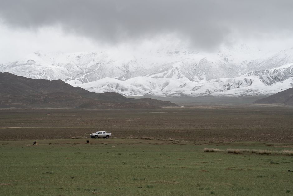
4. Qinghai Lake (青海湖) and Surrounding Area
Less demanding than the plateau treks, the Qinghai Lake circuit offers accessible high-altitude trekking at 3,196 metres with spectacular scenery. The full circumnavigation is 360 km — a multi-week route for dedicated long-distance walkers or cyclists. Day hikes and shorter sections are more practical for most visitors.
Niao Dao Bird Island (鸟岛): The lake’s western end hosts one of China’s largest migratory bird breeding colonies in May–June. The island has specific access routes during breeding season; ¥60 admission.
Cycling: The Qinghai Lake international cycling race has made the lake circuit famous in cycling circles; rental bikes available in Xining and at the lake town of Heimahe.
5. Zhiduo and the Greater Tibetan Plateau Grasslands
The grasslands around Zhiduo County (治多县) — one of the highest inhabited places in China at 4,066m average — offer exceptional wildlife opportunities without the permit restrictions of the core protected zones.
Wildlife seen regularly: Tibetan fox, golden eagle, Himalayan vulture, Tibetan gazelle, wolf, brown bear tracks. The density of raptors is extraordinary.
Accommodation: Basic Tibetan-run guesthouses in Zhiduo town; ¥80–¥120/night ($11–$17). Meals available at very limited options.

Essential Logistics
Getting to the Trekking Areas
Xining is the hub for all Qinghai trekking. From Xining:
- Yushu: Fly from Xining Caojiabao Airport to Yushu Batang Airport (1.5 hours; tickets ¥300–¥600, $42–$84). The altitude jump from Xining (2,276m) to Yushu (3,700m) is aggressive; allow extra acclimatisation time.
- Maduo / Amne Machen: Bus or arranged 4WD from Yushu or Golog (果洛); 5–8 hours on unpaved roads.
- Kekexili highway corridor: Qinghai-Tibet Highway bus from Xining (various services); the Kekexili section passes Wudaoliang.
4WD hire from Xining: For remote areas, a 4WD (typically a Toyota Land Cruiser) with driver is standard. Cost ¥800–¥1,200/day ($112–$168) depending on destination. Arrange through specialist agencies in Xining — recommended contacts include: Tibetan Plateau Adventure (青藏高原探险).
Guide Requirement
For serious trekking above 4,500m, a certified high-altitude guide is strongly recommended and in some areas required by regulation. Guides with genuine mountain experience (not city tour guides) can be hired in Xining or Yushu for ¥300–¥600/day ($42–$84).
Insurance
Standard travel insurance does not cover high-altitude trekking in most cases. Specialist adventure sports travel insurance covering altitude up to 6,000m and helicopter evacuation is essential. Check policies specifically for the Sanjiangyuan area.
What to Pack
Clothing:
- Down jacket (rated to at least -10°C) even in summer
- Waterproof shell jacket and trousers
- Warm base layers (merino wool recommended)
- Gaiters for stream crossings
Technical gear:
- Trekking poles (essential at altitude for balance and joint protection)
- Sleeping bag rated to -10°C for camping
- Portable altitude sickness medication (Diamox, dexamethasone — consult physician)
- Pulse oximeter (a small, inexpensive device; shows blood oxygen saturation — monitor daily)
- Satellite communicator (e.g. Garmin inReach) — critical in areas without mobile signal
Medical:
- Diamox (acetazolamide) — discuss with your doctor before departure
- Ibuprofen and paracetamol for altitude headache
- Oral rehydration salts
- First aid kit
Best Trekking Season
Mid-June to mid-September: The only practical window for most high-altitude routes. Summer temperatures at altitude are cool-comfortable during the day (8–18°C), cold at night (0 to -8°C), with afternoon thunderstorms common. The plateau flowers — columbines, gentians, primroses, edelweiss — are magnificent from late June.
Avoid: October–May. Heavy snow closes most routes, temperatures drop to -30°C on exposed plateau, and the risk of being stranded increases dramatically.
Final Word
Qinghai’s trekking wilderness is among the last genuinely wild landscapes accessible to determined independent travellers. The barriers — altitude, remoteness, permit requirements, expense — are real, but they also mean that the people you encounter in these mountains are either local Tibetan nomads or fellow travellers who’ve earned their place there. That changes the quality of the experience fundamentally.
Come prepared. Be patient with the altitude. And allow the scale of the Tibetan Plateau to recalibrate your sense of what “big” means.