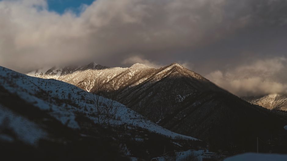
The Qilian Mountains: Qinghai’s Wild Alpine Frontier
Between the Hexi Corridor — the narrow strip of land through which the ancient Silk Road passed — and the vast Tibetan Plateau, the Qilian Mountain Range (祁连山) stretches 800 km along the Qinghai-Gansu border, rising to peaks above 5,800 metres. This is one of the most spectacular and least-visited mountain ranges in China: a world of glaciers, high-altitude grasslands, Tibetan nomad summer camps, and wildflower meadows that appear in July like an hallucination of colour after the grey of the plateau.
The Qilian Mountains generate the rivers that feed the oases of the Hexi Corridor — without this range’s glaciers and snowpack, the ancient cities of Zhangye, Jiuquan, and Dunhuang would not exist.
The Landscape
Elevation Zones
The range is dramatically stratified by altitude:
3,000–3,500 m (Lower Alpine Zone): Scrub willow and juniper; Tibetan yak pastures on the gentler slopes; small farming villages of Yugur and Tibetan communities.
3,500–4,200 m (Upper Alpine Meadow): This is where the Qilian reveals itself most dramatically in summer — vast, gentle slopes carpeted in wildflowers (gentians, edelweiss, Tibetan poppies in blue and yellow, primroses) from mid-June through early August. The meadows are grazed by yak herds; white Mongol-Tibetan yurts appear in the distance.
4,200–5,000 m (Alpine Rock Zone): Above the treeline; austere slopes of shattered slate and granite; occasional glaciers visible on north faces; ibex and snow leopard habitat (rarely seen).
Above 5,000 m: Permanent ice; only mountaineering teams.
Summer Wildflowers
The wildflower meadows between Menyuan (门源) and Qilian County Town (祁连县城) are one of China’s most remarkable summer landscapes. In July, fields of canola flowers (油菜花) — the same brilliant yellow as those in Luoping, Yunnan, but here framed by snow-capped mountains — extend across the valley floors. Higher up, alpine wildflowers create a patchwork of blue, purple, yellow, and white.
Peak canola season: Early July. Peak alpine wildflower season: Mid-July to early August.

Key Areas for Visitors
Menyuan Rapeseed Flower Sea (门源油菜花海)
The valley around Menyuan County (门源县) is at approximately 2,900 metres elevation. Its annual canola bloom — stretching for nearly 50 km along the valley — is one of the most dramatic agricultural landscapes in China. The contrast between vivid yellow and the dark Qilian peaks behind is exceptional for photography.
Getting there: Bus from Xining (4 hours, ¥60); or train to Haibei and taxi. Most visitors come on day-tour from Xining in early July.
Qilian County Town and Surrounding Valleys
Qilian County Town (祁连县城) at 2,787 metres is the main base for exploring the central range. From here:
- Bage Grassland (巴格草原): A broad, flat grassland 30 km north of town with summer yak herds and photogenic skylines.
- Tuo Lahai Valley (驼来寺沟): A 15 km hiking valley from the edge of town into increasingly steep alpine terrain; no facilities above the first 5 km.
- Horse-riding tours: Tibetan families offer horse rental (¥150–¥300/day) for grassland riding; multi-day horse-trekking to high meadows (with guide and camping gear: ¥800–¥1,200/person/day) is also available through operators in the county town.
Zhangye Qilian International Ecotourism Resort (张掖祁连山国际生态旅游度假区)
On the Gansu side of the range, this managed tourist area provides the most accessible approach to high-altitude Qilian scenery. The terrain here is less dramatic than the Qinghai side but more accessible.
Connection to Zhangye Danxia: Most visitors who come for the Zhangye Rainbow Mountains (Danxia) combine it with a day in the Qilian foothills — the two are about 1.5 hours apart.

Trekking Routes
Qilian County Town to Yema River Valley (野马河)
Difficulty: Moderate | Duration: 2 days | Max Elevation: 3,800 m
A classic introduction to the central Qilian that can be done without a guide by experienced trekkers. The route follows the Yema River upstream from the county town through increasingly open grassland, with views of permanent ice on the northern face of Qilian Main Peak (4,874 m).
Camping at approximately 3,500 m on the first night; return on the second day or continue to the high pass (3,800 m) for views of the far-side valleys.
Preparation: Carry all food and water from the county town; the single herder family checkpoint at km 15 does not sell provisions. Tent and sleeping bag rated to -10°C required (even in July).
Yeniugou Valley (野牛沟) Circuit
Difficulty: Strenuous | Duration: 4–6 days | Max Elevation: 4,200 m
A remote circuit through the eastern Qilian that includes crossing a 4,200 m pass and traversing three high-altitude grassland basins. This route is only appropriate for experienced mountain trekkers with navigation skills and cold-weather camping experience.
A local guide is mandatory — the route crosses unmarked terrain, and weather changes rapidly above 3,800 m. Guides available through the Qilian County Tourism Bureau (contact via WeChat).
Yugur and Tibetan Communities
The central Qilian is home to the Yugur people (裕固族) — one of China’s smallest ethnic minorities (approximately 14,000 people), speaking a Turkic language related to Uyghur and practicing a blend of Tibetan Buddhism and their own shamanistic traditions. Their traditional summer encampments on the high meadows are accessible by the track roads that wind into the foothills from Sunan County.
The Yugur are nomadic pastoralists; their traditional white felt tents (yurts with a distinctive Yugur decorative style) are recognisable by the blue and red border pattern. Visits to Yugur camps are best arranged through the county government’s tourism office in Zhangye or Sunan, which maintains relationships with families willing to host guests (¥100–¥200/person for a meal and cultural introduction; overnight stays possible).
Practical Information
Getting to the Qilian Area
From Xining (Qinghai capital):
- Bus to Qilian County Town: 4 hours (¥80).
- Bus to Menyuan: 2.5 hours (¥45).
- Self-drive rental from Xining is the most flexible option: G6 expressway (Beijing-Lhasa) passes through the range.
From Zhangye (Gansu):
- Bus or taxi to Qilian foothills: 1.5–2 hours.
Best Season
- Late June to August: Wildflowers at peak; long daylight hours; best trekking conditions.
- May and September: Cool, clear, less crowded; snow possible above 3,500 m.
- October–April: High passes closed; most accommodation in smaller settlements closed.
Altitude Awareness
Most of the Qilian valley floors are above 2,700 m. Travellers arriving directly from sea level (Xining is already 2,200 m) should spend at least one night in Xining before proceeding to higher altitudes. Acclimatisation is important even before the trekking begins.
The Qilian Mountains offer something increasingly rare in China’s most accessible destinations: the possibility of walking for an entire day and encountering no other foreign visitors. The landscape does not perform — it simply is, in the way that mountains and grasslands and cold stars always have been.