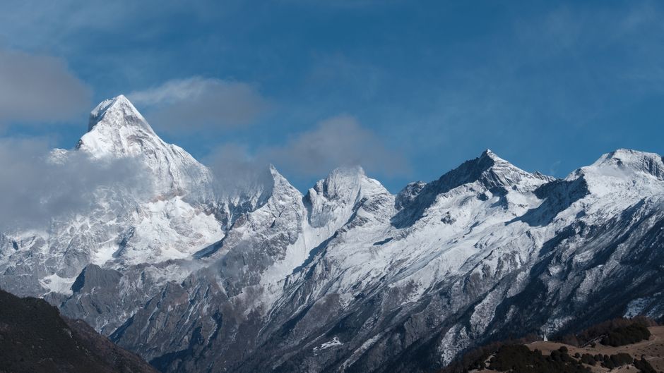
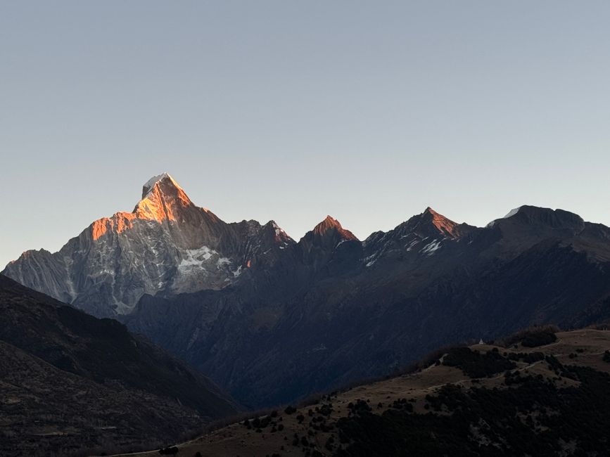
Siguniang Mountain (四姑娘山, “Four Girls Mountain”) is not one summit but a cluster of four peaks in the Qionglai Range of western Sichuan: Yaomei Peak (幺妹峰, 6,250m), the tallest, followed by Sanjie (三姐, 5,664m), Erjie (二姐, 5,454m), and Dajie (大姐, 5,355m). The name comes from a local Tibetan legend about four sisters who turned to stone to protect their homeland.
For Chinese outdoor enthusiasts, Siguniang is one of the premier alpine destinations — not for summit climbing (though the peaks attract technical climbers) but for the three spectacular valleys at the mountain’s feet that provide trekking routes ranging from easy walks to challenging multi-day wilderness circuits. The landscape combines snow peaks, glaciers, dense conifer and rhododendron forest, flower meadows, Tibetan farmsteads, and yak pastures into a concentrated zone of alpine scenery accessible from Chengdu in under 5 hours.
Table of contents
Open Table of contents
Getting to Siguniang Mountain
The base town for Siguniang is Rilong (日隆), a small Tibetan-Han settlement in the Shuangqiao Valley (双桥沟) at about 3,100m elevation.
From Chengdu:
- By bus: Buses from Chadianzi Bus Station (茶店子客运站) in northwest Chengdu; 4–5 hours; departures 7:00am and 8:00am; tickets ¥80–100
- By private car: About 3.5–4 hours via the G350 highway; route passes through Dujiangyan and Wenchuan (the city near the 2008 earthquake epicenter; the memorial park is accessible here)
- Via Wolong: Some travelers take the Wolong Giant Panda Reserve route as a stop on the way (adds 1–2 hours but worthwhile for panda fans)
Return buses to Chengdu: Depart Rilong around 7:00am; book the previous evening through your guesthouse.
Road conditions: The road is good and passes through scenically dramatic mountain terrain. In winter (December–February), snow and ice can affect the pass sections; check conditions before departing.
The Three Valleys
The three main scenic valleys each have distinct character and different entry fees:
Shuangqiao Valley (双桥沟) — The Accessible Valley
The widest, flattest, and most developed of the three valleys. An electric shuttle bus runs the length of the valley (12km each way), with stops at key viewpoints. This valley is best for:
- Visitors with limited trekking ability
- Those who want panoramic views of the four peaks without significant hiking
- Photography (the peak reflections in valley ponds are the classic Siguniang shot)
Highlights:
- Yala Snow Mountain viewpoint: Looking back toward a subsidiary peak from the valley floor
- Two Lakes (两个湖): Mirror-like high-altitude lakes reflecting snow peaks; photographed extensively in China travel media
- Tibetan village (藏族村寨): Traditional Tibetan farmsteads with prayer flags and yak herds; visible from the road
Entry fee: ¥120 per person
Shuttle bus: ¥60 round trip (additional to entry; strongly recommended)
Changping Valley (长坪沟) — The Trekking Valley
Changping is the premier trekking valley, a 12km long gully of increasingly dramatic alpine scenery accessible only on foot or by horse.
The main trail:
- Distance: 12km one-way from the trailhead; most visitors go in 5–6km and return
- Terrain: Well-marked path through mixed forest, alpine meadow, and rocky sections; some creek crossings
- Difficulty: Moderate; the altitude (trailhead at 3,200m; the valley rises to 3,700m) causes more exertion than the terrain alone
- Time: 5–6 hours for a comfortable return trip to the halfway point; full valley requires a turnaround at Haizi Valley floor or overnight camping
Highlights along the trail:
- Wolong Sea (卧龙海): A forest lake 3km in; excellent reflection of Yaomei Peak on clear days
- Maple Forest (枫树林): At 4–5km; in October, the maples turn orange-red, creating outstanding autumn photography
- Views of Yaomei Peak: The summit becomes increasingly imposing as you proceed up the valley
- Tibetan herder camps: Seasonal yak herding camps (May–October) where friendly locals may offer yak butter tea
Horses: Horse hire at the trailhead (¥150–250 for the first section; negotiate longer rides separately) allows less mobile visitors to experience the valley.
Entry fee: ¥100 per person
Haizi Valley (海子沟) — The Wildflower Valley
The smallest and least visited of the three valleys, Haizi is accessible from the town of Rilong by a separate trailhead and offers a different aesthetic: dense wildflower meadows, multiple high-altitude lakes (海子 literally means “highland lake”), and relatively few other visitors.
The main trail:
- Distance: 8km one-way to the highest lake
- Terrain: Steeper than Changping Valley; significant elevation gain (about 600m from trailhead to highest lakes)
- Difficulty: Moderate to challenging
Key features:
- Five Color Haizi (五色海子): A series of small high-altitude lakes with different mineral-tinted colors; reached in about 3–4 hours from the trailhead
- Wildflowers: Late May to early July brings extraordinary wildflower diversity — gentians, primulas, asters, and dozens of other alpine species carpet the meadows
- Mountain goats: Wild blue sheep (bharal) are occasionally seen on the rocky upper slopes
Entry fee: ¥60 per person

Multi-Day Treks
For experienced trekkers and those who want to see the mountain in full, several multi-day circuits are possible:
The Four Valleys Loop (3–4 days): A circuit connecting all three valleys via high passes (above 4,000m), requiring camping gear and good physical condition. This route is unmarked in sections — a local guide (¥300–500/day, plus their food and accommodation) is essential.
Rilong to Siguniang Mountain Base Camp: A 2-day trek reaching the technical mountaineering base camp below Yaomei Peak, with views of the entire massif. Elevation at camp: approximately 4,500m. Proper cold-weather gear and altitude acclimatization (at least 1 night in Rilong at 3,100m) required.
Permits for backcountry trekking: Multi-day backcountry routes require a trekking permit from the Siguniang Mountain National Park Management Office (四姑娘山景区管委会) in Rilong. Cost: ¥50–100 per person; provide a copy of your passport. For multi-day routes, registering with the Mountain Rescue station at the scenic area office is strongly recommended.
Accommodation in Rilong
Rilong has a solid selection of guesthouses and small hotels serving trekkers and hikers:
Budget guesthouses (客栈): ¥100–180/night; basic but functional; most include breakfast; many are run by local Tibetan families Mid-range inns: ¥200–380/night; slightly better rooms, private bathrooms; some with mountain views Top-end options: A few newer boutique-style lodges (¥450–800/night) have opened to serve the growing premium tourism market; amenities include heated rooms and good restaurants
Altitude adjustment: Rilong sits at about 3,100m. If coming directly from Chengdu (500m), most people experience mild altitude symptoms (headaches, breathlessness) on the first night. Rest, avoid alcohol, and don’t begin trekking until the second day if possible.
When to Visit
Best months: May to October
May–June: Wildflower season in Haizi Valley; rhododendrons bloom across the valley slopes; snow still visible on peaks; relatively uncrowded on weekdays.
July–August: Peak season; the most accessible and comfortable weather; afternoon cloud builds but mornings are clear. Crowded on weekends and during national holidays.
September–October: The finest season — clear blue skies, golden larches and maple forests, excellent summit visibility, significantly fewer visitors. The photography conditions in October are outstanding.
Winter (November–April): Below-freezing temperatures; valleys are beautiful under snow but most guesthouses reduce operations or close. High trails may be impassable due to snow.
Practical Tips
Altitude sickness prevention: Ascend slowly. One night in Rilong (3,100m) before trekking is the minimum; two nights is better. Diamox (acetazolamide) is available in Chengdu pharmacies for those who are susceptible to altitude sickness.
Weather: Mountain weather changes rapidly; afternoon cloud and brief showers are normal. Start treks early (7–8am) to maximize clear conditions.
What to bring: Trekking poles (available for rent in Rilong; ¥20/day), warm layers (even in summer; temperature drops significantly with altitude), waterproof jacket, sun protection (UV is intense at altitude), snacks and water.
Mobile coverage: Good in Rilong and the main valley floors; weak to nonexistent on upper trails. Download offline maps before your trek.
Environmental note: Siguniang Mountain is a national nature reserve and UNESCO World Heritage site candidate. Pack out all litter; stay on marked trails; do not disturb wildlife.